


© El Brogit - 24/04/2024 00:17
Walking and wine holidays in Catalonia

Ecotourism, walking and wine tourism in Catalonia: book local with us!
The Brugent Valley is situated at the heart of Muntanyes de Prades, Area of Natural Interest which comprises a group of mountains of great ecological value. They take up an area of about 260 square km in the region of Tarragona. The major mountains surrounding and protecting the interior of the Brugent Valley are the Serra del Bosc de Poblet (Range of the Forest of Poblet), on the north, and the high plateau of Els Motllats on the south. All of them are over 1.000 metres high.
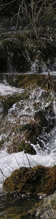
The slopes of Els Motllats give birth to the river Brugent, the most important shaping agent of the Valley over thousands of years. From the river source, at Font de la Llúdriga (fountain), its crystal clear, fresh water irrigates the fertile plain where the village of Capafonts rises. The water endlessly cascades through beautiful ravines, waterfalls and pools. After travelling along the lands of Farena, the Brugent flows into the river Francolí, by la Riba, which is its major tributary.
The Brugent Valley hosts an important biodiversity, including species from continental to Mediterranean climates and the refreshing vegetation of the river banks. As an example, this extraordinary Valley hosts everything from maple trees to palm hearts, from polecat to Bonelli’s eagle.
The Valley has been inhabited since ancient times. This is proved by the numerous cave paintings about 10.000 years old. During the centuries, the use of the natural resources and above all, of the river, has changed. Using the motive force of the water, many hydraulic mills were built along the Brugent river. Their ruins can still be seen nowadays, along the itinerary. They remind us that this river belonged to the second paper-producing basin of Catalunya.
Programa Kit Digital, cofinanciado por los fondos europeos Next Generation (EU) del mecanismo de recuperación y resiliencia.

© El Brogit - 24/04/2024 00:17
Walking and wine holidays in Catalonia


